We use cookies to make your experience better. To comply with the new e-Privacy directive, we need to ask for your consent to set the cookies.
Toggle Nav

The Evolution of the Topo Map
NatGeo Maps evolves the topo map for extreme and casual adventures
With nearly 300 map titles covering North America’s most popular parks and outdoor recreation areas, National Geographic’s Trails Illustrated (TI) topographic trail maps have been the go-to maps for serious hikers, backpackers, and outdoor adventurers since the 1990’s. Based on topographic maps and data from the U.S. Geological Survey, U.S. Forest Service, National Park Service, Geological Survey of Canada, and Parks Canada, plus rigorous research and review with local land managers, TI maps provide the gold standard for topographic trail maps in the United States and Canada.
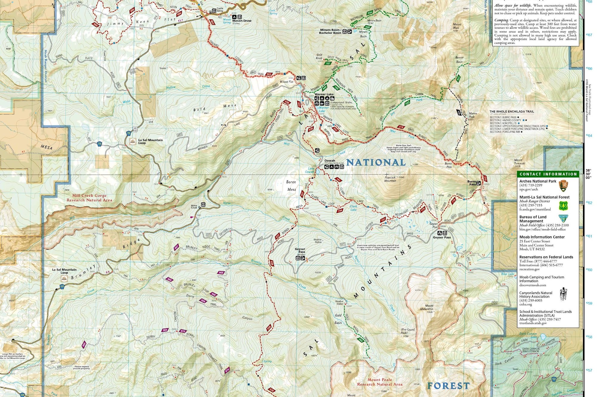
Updated regularly, TI maps are used extensively by search and rescue teams to find people lost in the backcountry, and by outdoor adventure guides to plan routes and lead clients in and out of remote wilderness areas. With their distinctive gold covers and bold, descriptive titles, the durable folded maps provide a treasured physical collection of outdoor memories and aspirations for experienced outdoor adventurers.
Seasoned backpackers and hikers revel in large folded topo map sheets, painted with a plethora of winding trails and elevation contours, intriguing points of interest, and helpful map notes. Given ample time, they love exploring the endless possibilities represented by a large folded sheet map, using it as a rich tabula rasa to craft and curate their own adventure routes. But DIY adventure planning is not for everyone.

Most nature lovers only have the time, interest, and ability to explore the outdoors through day hikes on well-trodden routes. People new to outdoor exploration or those with limited time for research and route-crafting want experts to guide them to the most interesting and accessible places—the “best” tried-and-true routes and must-see sights. This includes the 10 million people in the U.S. who, since the covid-19 pandemic, discovered hiking as a safe and fun outdoor activity.
National Geographic’s series of Day Hikes Topographic Map Guides booklets are filling the need for curated casual hiking maps. They represent a new category of topographic map that has evolved in recent years through innovation and testing by the cartographers at National Geographic, beginning with iconic long distance trails, and culminating in their new series of National Park Day Hikes.
Crafting a topographic map experience for long distance trails
In 2014 National Geographic began experimenting with a new small booklet format for topographic maps, tailored to long distance thru-hikers, starting with the John Muir Trail (JMT), a long distance trail that traverses 214 miles (344 kilometers) of California’s Sierra Nevada Range. The format was immediately popular with JMT thru-hikers and section hikers, leading to the development of topographic map guide booklets for other long distance trails, including the Appalachian Trail (AT), Pacific Crest Trail (PCT), the Colorado Trail (CT), the Tahoe Rim Trail (TRT), and the Haute Route in the Alps.
The Topographic Map Guide format is a user-friendly and light-weight saddle-stitched 50-page booklet—the same size and weight as a folded-up trail map—printed on the same durable waterproof, tear-resistant paper as standard Trails Illustrated maps. The booklet maps are based on the TI sheet maps, and in some cases, are updated and enhanced with additional details and thru-hiking information.
Laser-focused on the content needed for trail navigation, each of the booklets’ 16-18 map two-page spreads includes a detailed topographic map centered on the trail. Along the bottom of each spread is a trail profile that shows the elevations, landmarks, facilities, trail junctions and access points along that section of trail, with distance intervals keyed to the map. Together, the map and trail profile provide a step-by step visual geographic guide to hiking the trail.
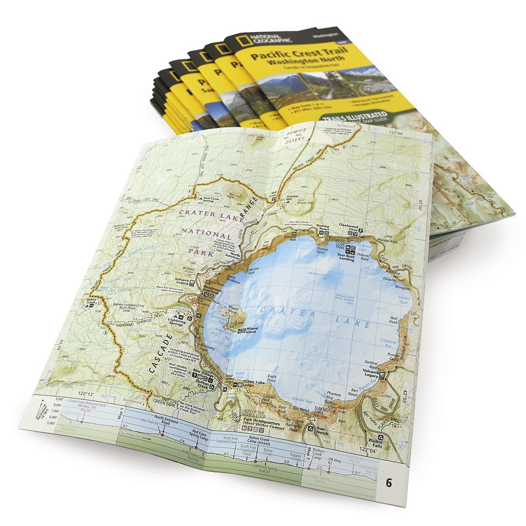
The 8-10 pages of front matter include an index map, concise trail overview and history, resupply locations, key points of interest, safety guidelines, and key information needed to plan a safe and memorable long distance backpacking trip. To limit each booklet to the same small size and weight, very long trails like the AT and PCT are divided into a group of a dozen or so booklets, one for each major section, to cover the entire trail at 1:63,360 or 1:75,000 scale.
With the success of its Topographic Map Guide booklets for the JMT, AT, PCT, and CT, NatGeo Maps is exploring the development of booklets for other iconic long distance trails in North America and around the world, in partnership with local experts, cartographers, and data providers. It has also extended the format to other types of outdoor recreation beyond backpacking, including river recreation and day hiking.
From long trails to river corridors
Like long distance trails, rivers are linear features that receive focused recreation activity along a narrow band of the landscape, for which the booklet format is optimized. National Geographic’s Fishing and River Recreation Map Guides each provide a series of map spreads centered on a river corridor, with information to support fishing, paddling, and other water-focused river activities.

One of the hardest parts of finding a new fishing or paddling spot is determining parking and access locations. So these booklets clearly show access points and the patchwork of ownership that is typical of the land adjacent to rivers. They also provide useful localized information about the river segments, water levels, river uses, and regulations, as well as the type of fish inhabiting the stream and seasonal insect hatch charts.

From the valleys to the summits
The durable lightweight booklet format proved itself handy and effective for backpackers and anglers to navigate long trails and sequential river segments. But with the Colorado 14ers series of Topographic Map Guide booklets, the format has also been proven for collections of separate discrete trails, as represented by Colorado’s 54 mountain peaks higher than 14,000 feet (4,267 meters), most of which can be summited by experienced hikers in a single challenging day.
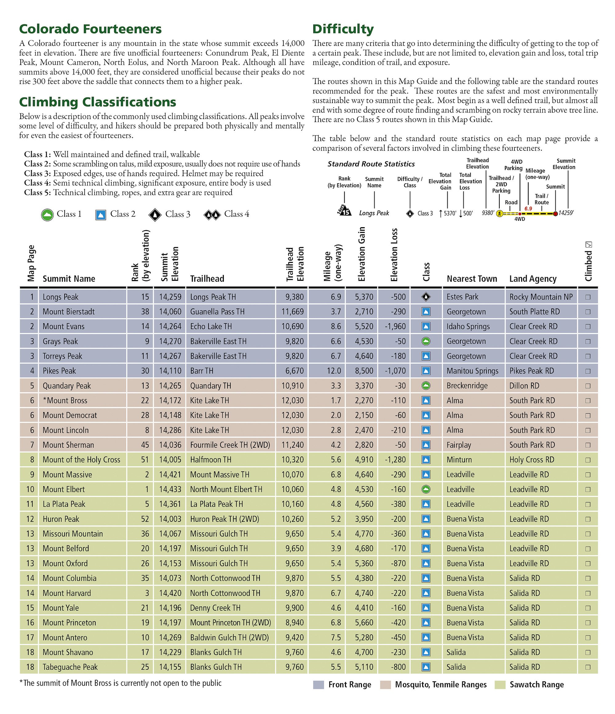
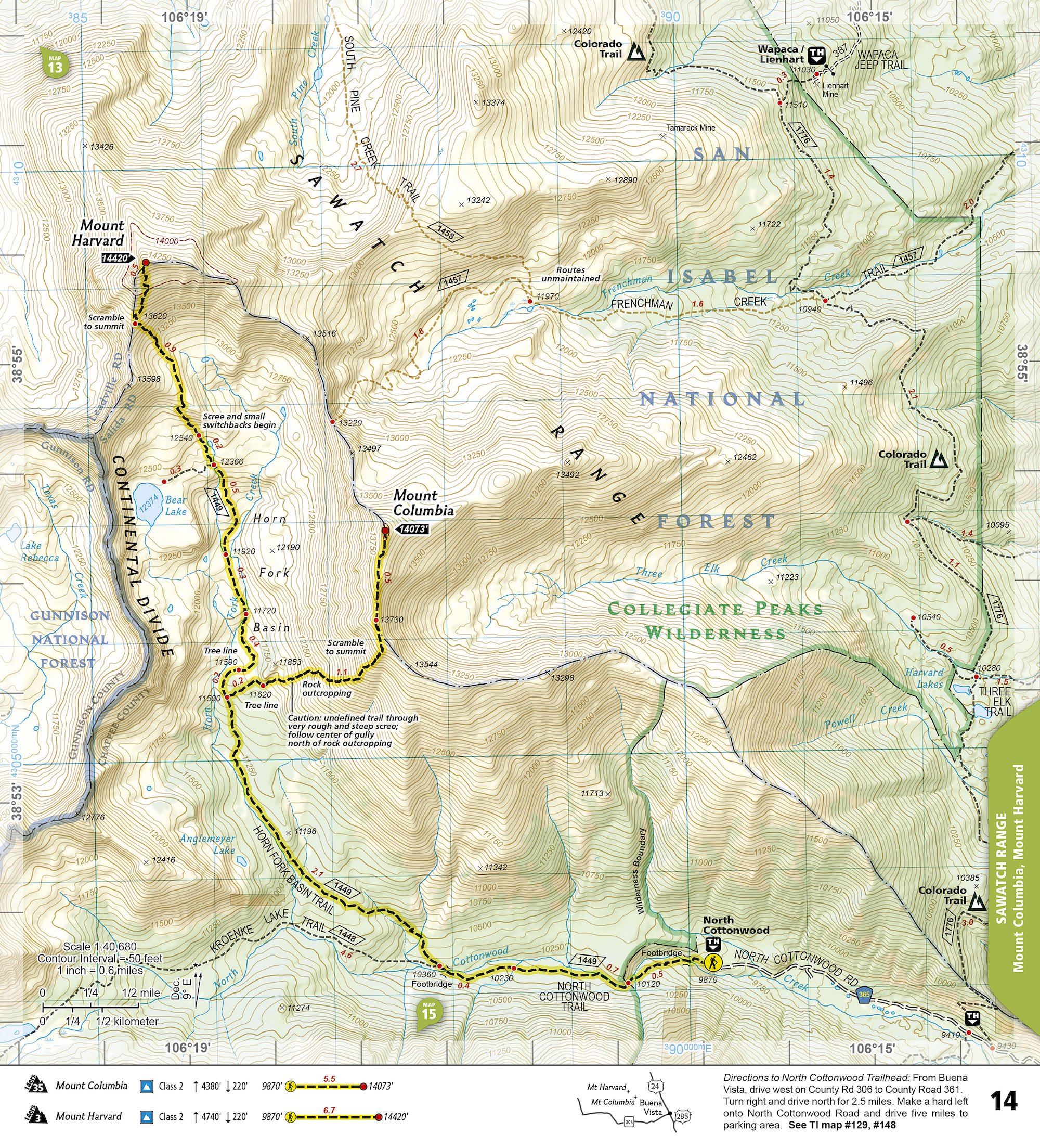
In these booklets—published in 2019 as a group of two map guides covering all of the 14er hikes in Colorado’s northern and southern ranges—each map spread provides accurate trail statistics including trail mileages, total elevation gain and loss, trailhead elevations and elevations at trail junctions, and directions to trailheads. Route information includes climbing class (i.e. difficulty rating) and points of reference along the route. The maps include both 2WD and 4WD trailhead locations for the standard, recommended route to the summit.
Once again, the lightweight booklets provide a handy alternative to thick and verbose books and hiking guides with their simple generalized maps, or the large group of detailed folded maps required to cover that same collection of hikes with sheet maps.
Curating the National Park hiking experience
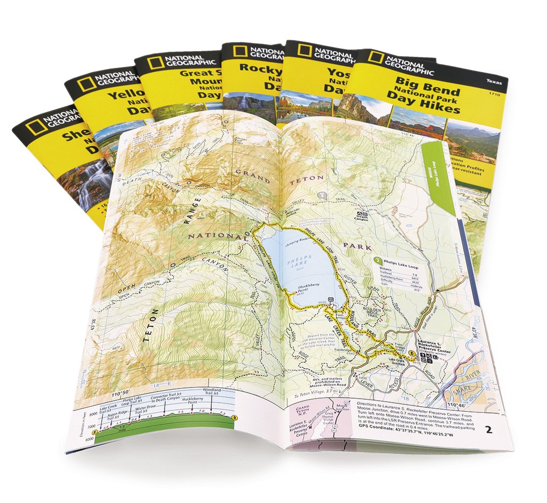
With the booklet proving an effective format for collections of discrete hikes in a particular region, National Geographic’s cartographers were inspired to reimagine how the format could be applied to day hikes in America’s premier national parks. That has resulted in the creation of the new series of National Park Day Hikes Topographic Map Guides, starting with Yellowstone, Grand Teton, Yosemite, Great Smoky Mountains, Shenandoah, Rocky Mountain, and Big Bend national parks in the United States.
The National Park Day Hikes booklets provide a curated collection of maps and information for a diverse selection of day hikes in each national park, carefully selected and mapped by the cartographers and outdoor experts at National Geographic, with park managers' input. Also printed on durable waterproof, tear-resistant paper, they are designed for quick and convenient access to the information needed for trail discovery, selection, and navigation within national parks.
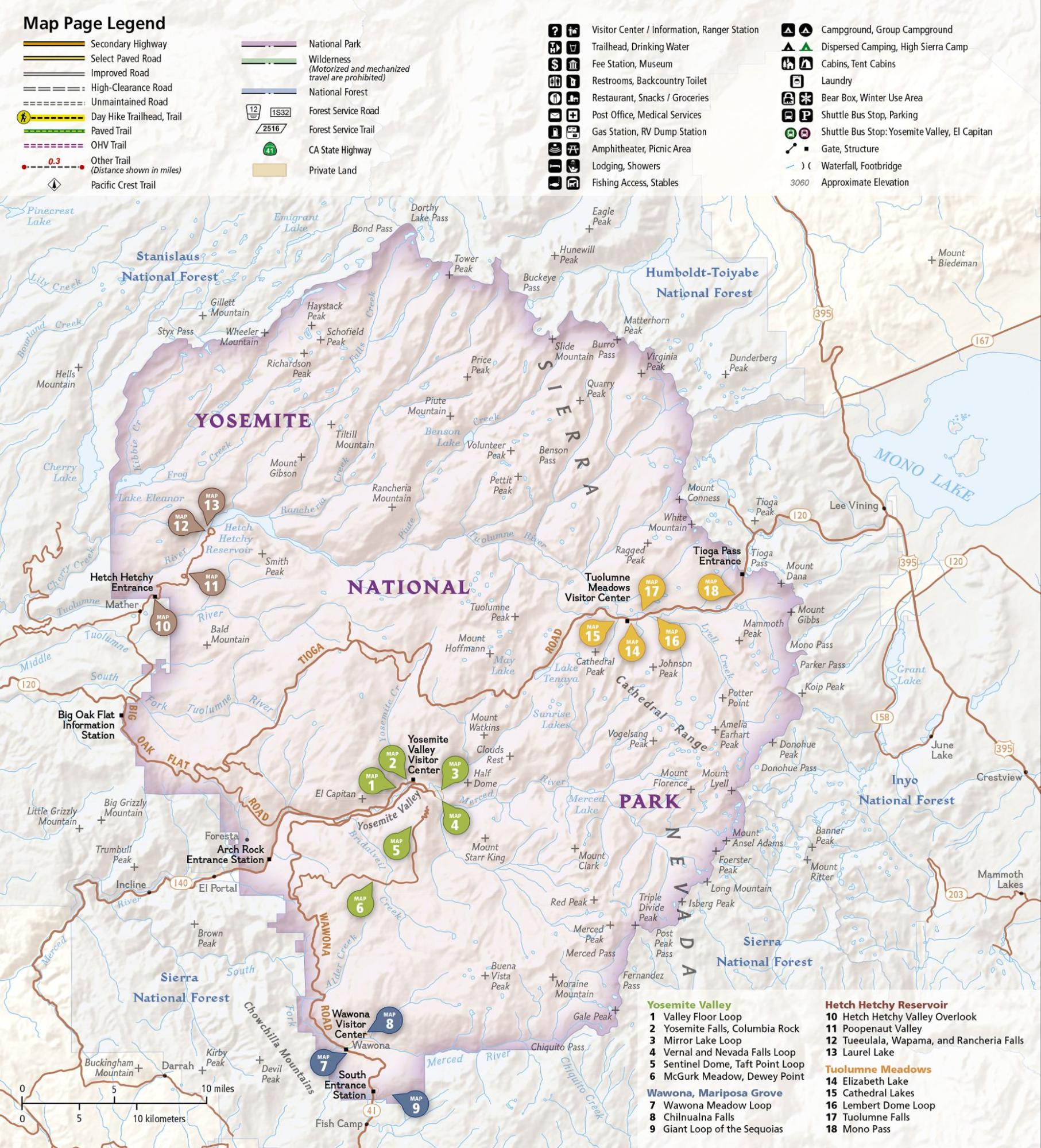
The two front pages provide an overview locator map of the park, showing each of the day hikes color-coded by the section of the park that they fall within, corresponding to the book sections by which the maps are organized. Front pages also include a concise overview and history of the park and brief descriptions of each hike with difficulty ratings, distance, and elevation gain, followed by park-specific health and safety information and day-use rules and regulations.
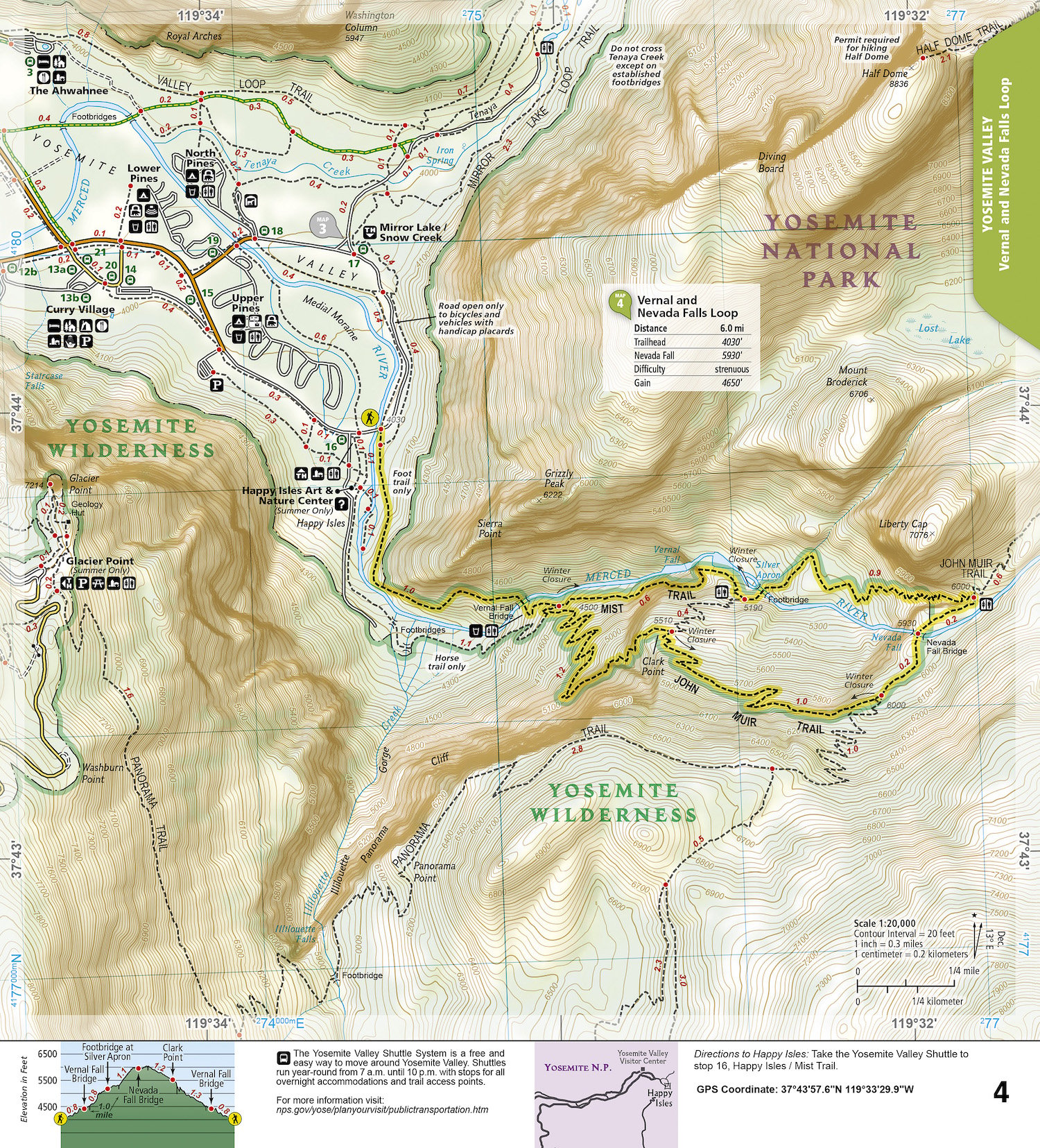
Like the 14ers booklets, each two-page map spread includes a detailed topographic map centered on a highlighted day hike. Along the bottom of each map is a trail profile showing elevations, landmarks, trail junctions, and distance intervals keyed to the map, along with GPS coordinates and directions to the trailhead.
The format is perfect for casual exploration of National Parks through day hikes. Even the National Geographic cartographers who are avid adventurers turn to the booklets when they are exploring the parks on day hikes with their family and friends. The handy and quick format and easy reference of the booklets, perhaps in combination with a mapping app, is all that is needed to get the most out of a visit to a national park.
Visit NatGeoMaps.com for more information about National Geographic’s Topographic Map Guides and other Trail Maps, Travel Maps, and Wall Maps.