We use cookies to make your experience better. To comply with the new e-Privacy directive, we need to ask for your consent to set the cookies.
Toggle Nav


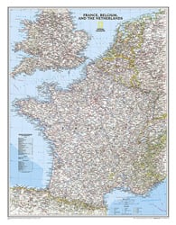
France, Belgium, and The Netherlands Classic Map
Expertly researched and designed, National Geographic's Classic style political map of France, Belgium, and The Netherlands features clearly defined international boundaries, thousands of place names, waterbodies, airports, major highways and roads, national parks, and much more. Also shown are the region's updated infrastructures, including major oil fields and pipelines; high-speed passenger railway lines; canals; and ferry routes. The tasteful color palette, shaded relief, and bathymetric... Read More


Avenza Maps App | ||
| The Avenza Maps App offers an ala-carte download of single National Geographic maps, on which you can see your current GPS location and use the app’s navigation, tracking and data collection tools, either online or offline. Click on the link below to purchase a digital version of this map for the Avenza Maps App. Requires a free download of the Avenza PDF Maps app. | ||
| $9.99 | France, Belgium, and The Netherlands Classic Map | |
| Product Code | RE00622074 |
|---|---|
| ISBN | 9780792283362 |
| UPC | 749717004658 |
| Folded Size | No |
| Flat Size | 23.5" x 30.25" |
| Scale | 1:1,955,000 |
| Copyright Date | 2016 |
| Weight Oz | 2 |
| Dim Thickness | No |
| Page Count | 1 |
| Case Quantity | 200 |


