We use cookies to make your experience better. To comply with the new e-Privacy directive, we need to ask for your consent to set the cookies.
Toggle Nav


![Wind River Range North Map [Pinedale, Dubois]](https://images.natgeomaps.com/PROD_SM_250px/TI00000727_0_SM.jpg)
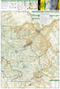
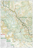
727 :: Wind River Range South Map [Lander, Cirque of the Towers]
$14.95
• Waterproof • Tear-Resistant • Topographic Map
The Wind River Range of northwest Wyoming encompasses an area of more than 3,500 square miles. Locally known as just "The Winds", the range contains a unique combination of jagged granite rock, alpine forest, open meadows, over 1,300 named lakes, and the largest glacier in the American Rockies. Recreation opportunities are distributed across the landscape with hiking, camping, fishing, climbing and snowmobiling to list just a... Read More

Avenza Maps App | ||
| The Avenza Maps App offers an ala-carte download of single National Geographic maps, on which you can see your current GPS location and use the app’s navigation, tracking and data collection tools, either online or offline. Click on the link below to purchase a digital version of this map for the Avenza Maps App. Requires a free download of the Avenza PDF Maps app. | ||
| $14.99 | 727 :: Wind River Range South Map [Lander, Cirque of the Towers] | |
| Product Code | TI00000727 |
|---|---|
| ISBN | 9781566958271 |
| UPC | 749717054264 |
| Folded Size | 4.25" x 9.25" |
| Flat Size | 25.5" x 37.75" |
| Scale | 1:70,000 |
| Copyright Date | 2021 |
| Weight Oz | 3 |
| Dim Thickness | No |
| Page Count | 2 |
| Case Quantity | 200 |


